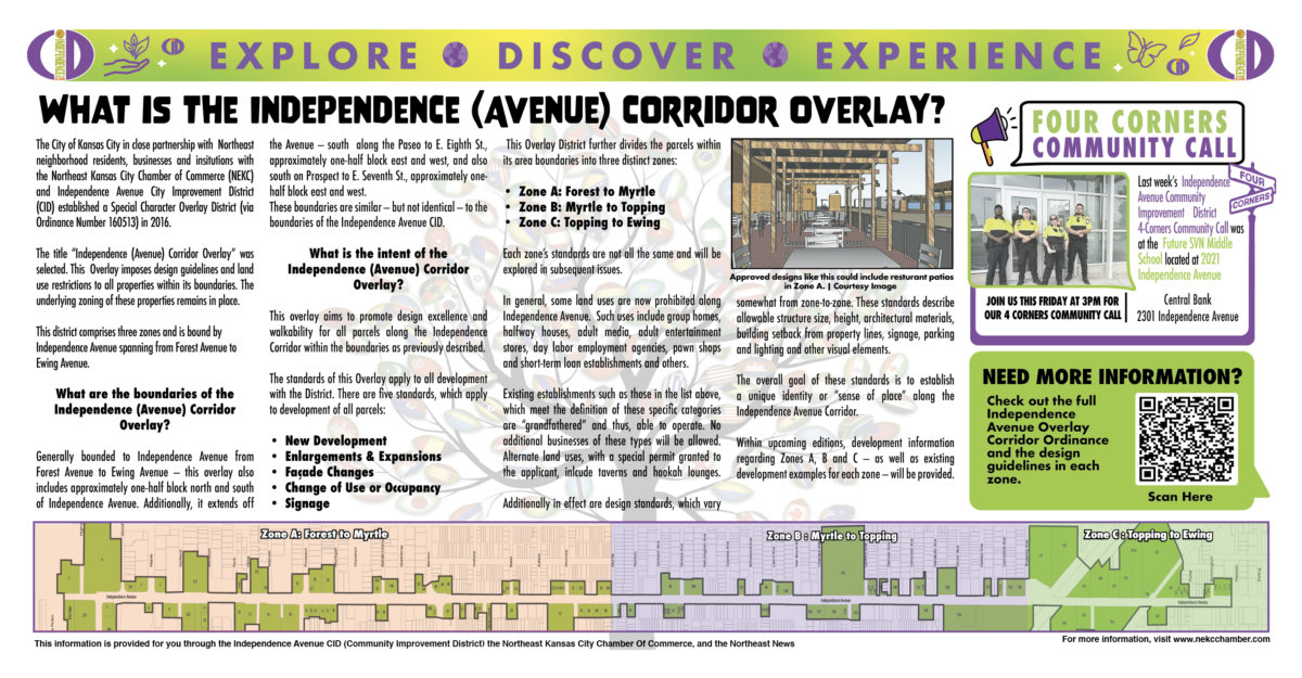
The City of Kansas City in close partnership with Northeast neighborhood residents, businesses and institutions with the Northeast Kansas City Chamber of Commerce (NEKC) and Independence Avenue Community Improvement District (CID) established a Special Character Overlay District (via Ordinance Number 160513) in 2016.
The title “Independence (Avenue) Corridor Overlay” was selected. This Overlay imposes design guidelines and land use restrictions to all properties within its boundaries. The underlying zoning of these properties remains in place.
This district comprises three zones and is bound by Independence Avenue spanning from Forest Avenue to Ewing Avenue.
What are the boundaries of the Independence (Avenue) Corridor Overlay?
Generally bounded to Independence Avenue from Forest Avenue to Ewing Avenue — this overlay also includes approximately one-half block north and south of Independence Avenue. Additionally, it extends off the Avenue — south along the Paseo to E. Eighth St., approximately one-half block east and west, and also south on Prospect to E. Seventh St., approximately one-half block east and west.
These boundaries are similar — but not identical — to the boundaries of the Independence Avenue CID.
What is the intent of the Independence (Avenue) Corridor Overlay?
This overlay aims to promote design excellence and walkability for all parcels along the Independence Corridor within the boundaries as previously described.
The standards of this Overlay apply to all development with the District. There are five standards, which apply to development of all parcels:
- New Development
- Enlargements & Expansions
- Façade Changes
- Change of Use or Occupancy
- Signage
This Overlay District further divides the parcels within its area boundaries into three distinct zones:
- Zone A: Forest to Myrtle
- Zone B: Myrtle to Topping
- Zone C: Topping to Ewing
Each zone’s standards are not all the same and will be explored in subsequent issues.
In general, some land uses are now prohibited along Independence Avenue. Such uses include group homes, halfway houses, adult media, adult entertainment stores, day labor employment agencies, pawn shops and short-term loan establishments and others.
Existing establishments such as those in the list above, which meet the definition of these specific categories are “grandfathered” and thus, able to operate. No additional businesses of these types will be allowed. Alternate land uses, with a special permit granted to the applicant, inlcude taverns and hookah lounges.
Additionally in effect are design standards, which vary somewhat from zone-to-zone. These standards describe allowable structure size, height, architectural materials, building setback from property lines, signage, parking and lighting and other visual elements.
The overall goal of these standards is to establish a unique identity or “sense of place” along the Independence Avenue Corridor.
Within upcoming editions, development information regarding Zones A, B and C — as well as existing development examples for each zone — will be provided.
JOIN US THIS FRIDAY AT 3PM FOR
OUR 4 CORNERS COMMUNITY CALL:
Central Bank
2301 Independence Avenue