Abby Hoover
Managing Editor
Columbus Park residents are voicing their concerns over a plan to tear down and reconstruct Route 9 at grade on the western border of their neighborhood, which is bordered to the south and east by I-35.
The Bridging Park and Market project is being led by the Downtown Council of Kansas City. Project planners are currently gathering input on proposed changes to Route 9 and Independence Avenue through the Columbus Park and River Market areas.
On November 25, the Columbus Park Community Council and residents met with Jayne Siemens and Olsson’s Jeff McKerrow from the project team. An online open house and resident survey, which closed Sunday, Nov. 29, outlined four options to consider.
The ultimate goal of this road reconfiguration project is to provide a more livable, safe and connected community that encompasses multimodal transportation, according to the Downtown Council. At this time, there is no identified funding to make any of the proposed changes.
The study looks at the concept of bringing Route 9 back to grade between I-70 and the Heart of America Bridge over the Missouri River.
“This includes restoring Independence Avenue connections to the River Market and Central Business District, repairing an important, broken connection to East Kansas City,” according to the study.
The Planning and Environmental Linkages (PEL) study, or “Beyond the Loop,” completed in 2018 by the Mid-American Regional Council (MARC), the City of Kansas City, Mo., and MoDOT focused on the US-169 corridor from Route 9 to I-35. The study recommended making the changes this project is working toward.
The four concepts can occur within existing right-of-way, with no additional property acquisition anticipated, according to the project’s website. Some of the concepts might provide the opportunity for existing right-of-way to be purchased from the Missouri Department of Transportation (MoDOT) and utilized for development.
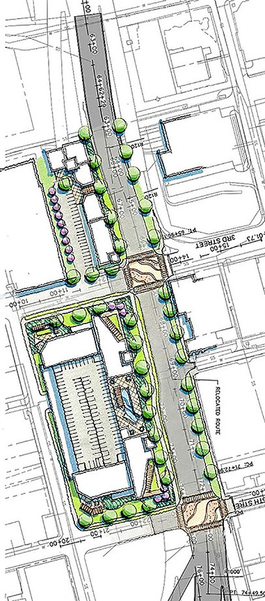
The proposal includes pedestrian enhancements at 3rd and 5th streets where the current bridge underpasses are poorly lit and have sloped walls, leaving a narrow sidewalk for pedestrian traffic.
One proposed way to improve the connection west from Columbus Park to River Market is to open up the underpasses, which could be done without changing current traffic patterns. This option is estimated to cost between $800,000 and $900,000.
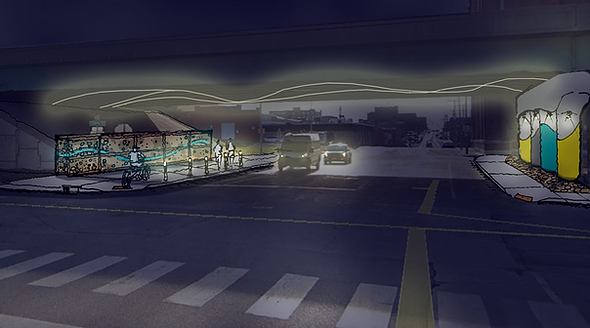
Columbus Park residents voiced concerns about the safety of pedestrian and bike crossing if Route 9 returns to grade. Route 9 would have two to three lanes of traffic, then a median, then two to three more lanes traveling in the opposite direction. Project leaders said they would lower the speed limit and add signalized intersections and crosswalks.
The project calls current access to Route 9 from the surrounding freeway system “somewhat complex,” with many options that utilize direct ramps or a collection of local streets.
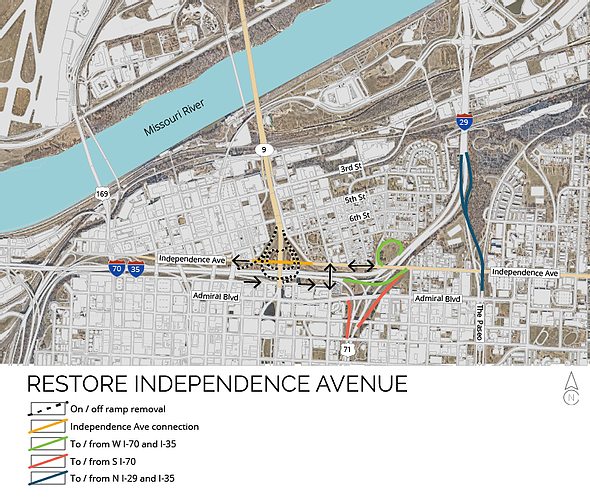
“Instead of focusing on the freeway system, the concept of reconnecting Independence Avenue emphasizes the local street network,” according to planners. “With the loop ramps that exist today at the I-70 and Route 9 interchange, reconnecting Independence Avenue would be difficult and expensive, if not impossible while maintaining current design standards.”
By reconnecting Independence Avenue with a signalized intersection at Route 9, planners hope to use the existing street network to provide connections to the freeway system and Route 9, relying on Independence Avenue to provide critical movements and keep traffic passing through the area out of Columbus Park and River Market.
I-70 ramps would be removed if this option progresses, opening up the possibility for excess land to be purchased and developed where the on-ramp loops are today. This option is estimated to cost between $6.2 and $6.8 million, not including the cost to acquire property from MoDOT for redevelopment.
With the avenue reconnected, Route 9 could be lowered and signalized intersections added at 3rd and 5th streets.
“While it would be physically possible to do this and maintain the I-70 interchange, the impact to that change on Cherry Street would likely shift traffic passing through the area into the Columbus Park neighborhood, which is an undesirable situation,” according to the study.
Instead, one option would be to shift Route 9 east to utilize some of the existing Cherry Street alignment, which would leave a significant amount of land west of Route 9 vacant. A new bridge structure would need to be constructed north of 3rd Street, tying into the Heart of America Bridge near 1st Street.
This option is estimated to cost between $13.4 and $14.8 million. The Independence Avenue connection must be made for this to be a viable option, and would raise the total project costs to between $19.6 and $21.6 million.
A second option would be to utilize the existing 3rd Street exit ramps, which would allow the bridge to be removed south of 1st Street. The ramps are wide enough to accommodate two lanes of traffic in each direction, but would require the addition of a new pedestrian/bicycle bridge.
Called the “Boulevard Concept,” this option would provide less opportunity for new development, but would create a mini boulevard centered around 3rd Street for pedestrian activities, including a dog park relocated from between 3rd and 5th streets.
This project, estimated between $11.5 and $12.6 million, also relies on the execution of the Independence Avenue connection, which would bring total costs up between $17.7 and $19.4 million.
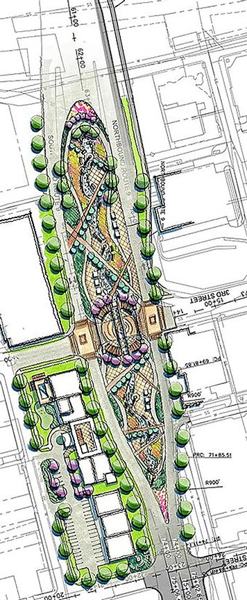
“It is worth noting that, by utilizing the existing ramp bridges, this project costs nearly $2 million less than the Eastern Alignment option,” according to the study. “That said, the cost does not assume the full development of the park in the Boulevard, which would add additional costs.”
Residents questioned the maintenance of the boulevard option’s green space, which McKerrow said would most likely not be MoDOT’s responsibility but rather a community improvement district or the Parks Department. He said removing bridges, embankments and roadways lessens maintenance obligations for MoDOT, so they would probably be in favor.
Some of the initial concepts included a new intersection of Route 9 and 6th Street, where it currently passes over, but the grade is too steep between 6th Street and Admiral for that to work further to the south.
Other ideas kept Route 9 as it currently exists over I-70 and 6th Street, but included an at-grade intersection with Missouri Avenue. That option has since been scrapped, as it would be “very disruptive” to Columbus Park and doesn’t work as it comes down off I-70.
In the late 1980s, the latest phase of Route 9 highway expansion was completed. Less than 20 years later, formal recommendations to lower Route 9 emerged in 2005 in the Kansas City Downtown Corridor Strategy.
Prior to the construction of those highways in the 1950s, Columbus Park, then known as the North End, was connected to the River Market and Paseo West neighborhoods. When the highway construction came through, buildings in the path were demolished. They included the four-plexes, businesses and houses familiar to the area.
Again in 1987, more land was taken for development when the Heart of America Bridge was constructed and the highways were expanded.
The impacts from decades of highway construction and reconfiguration left Columbus Park in an oft forgotten pocket, walled off from nearby districts. Residents and business owners have adapted over the years, but with the potential land for sale, residents are concerned that instead of single-family homes or small businesses, large corporations or developers will out-bid them. High rises or dense residential buildings would undoubtedly increase traffic through their quiet neighborhood.
For homeowners on Holmes Street, the biggest concern was the nature of the buildings that could move into that reclaimed land. They questioned what it would do to their property values and said there is already truck traffic all night long, so if it’s lowered, they have concerns about noise, pollution and safety.
Heading east down Independence Avenue, a $30 million Choice Neighborhoods Grant was awarded to redevelop the Paseo Gateway area, including the intersection of Independence Avenue and the Paseo and the redevelopment of the Chouteau Courts site, which sits between Pendleton Heights and Columbus Park.
McKerrow said they will look at all the options and determine what’s feasible, and then measure the costs. The next step is checking off things that need to be done to implement a plan, like environmental reviews, a noise study and coordination with the federal highway department.
“Ultimately, it’s going to be – like a lot of things – it’s the elected officials who kind of draw this conclusion, and it will be the decision of Kansas City elected officials [if they] have that desire to make this change, and it will likely fall to them,” McKerrow said.
The project group is not making a recommendation, rather presenting realistic options to give people an understanding of the process and the impact. The final report is anticipated before the end of the year.
“Our final report will document the cost impact of the feasible options, as well as the community input, to help inform state and local officials on what steps, and their associated costs, would be necessary to advance any of these plans,” according to the website.
It will include input from stakeholders, business owners and residents of downtown, Columbus Park, North Kansas City and River Market. Where feasible, the options may be refined or added to reflect the comments received. Should state and local leaders decide to move forward with any of the options, additional studies, public comments, and federal reviews will be necessary.