By MICHAEL BUSHNELL
Northeast News
September 26, 2012
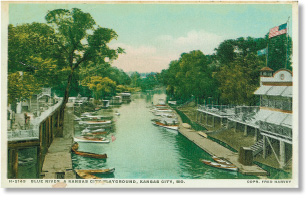
What is now nothing more than a re-routed, re-manufactured drainage ditch north of 63rd Street was once home to thousands of boat owners in the Kansas City and Independence area who made their summer home along the banks of the beautiful Blue River.
This historic postcard published by the Fred Harvey Company shows the Blue River looking North from 15th Street (Truman Road). Canoe and boat rental outfitters lined the banks of the Blue with names like the Star Boat Company and the Blue River Boat House, shown at left in the view on this postcard. Farther north, near where 12th Street crosses, was the Kansas City Yacht Club. In this view, the Blue River seems to be full, but other views of the same time period show the river as barely a trickle where one could wade across its breadth and not get completely wet in the process.
With the pending encroachment of industry along its banks, recreation-based businesses closed their doors one by one, and the river became a dumping ground for everything from industrial waste to rusting automobiles to household items. Today, the river, north of 12th Street to the northern border of the old Sheffield Steel Mill, flows in a narrow concrete channel largely for flood control purposes. Virtually no evidence exists of what was once known as Kansas City’s water playground.


