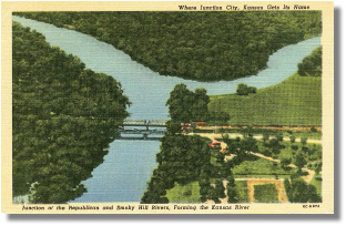
This Linen style postcard published by the P.K. News Company of Junction City, Kan., shows the confluence of the Republican and the Smoky Hill Rivers, forming the Kansas River.
The description on the back of the card states: “Junction City proper lies just southwest of the confluence of the rivers. This progressive community, located on Highways US 40 and US 77 is known as ‘The gateway to Fort Riley’, being adjacent to the 51,000 acre military reservation of Fort Riley which was established in 1852.”
The Republican River is named for a branch of the Pawnee Indians known as “the republicans.” It is formed by the confluence of the North Fork Republican River and the Arikaree River in Dundy County, Neb., and flows generally eastward along the Kansas-Nebraska border before curving southward into the Smoky Hills region of Kansas.
The Smoky Hill River derives its name from the Smoky Hills region of Kansas through which it flows. Its headwaters lie on the high plains of central Colorado and flows eastward through north central Kansas through Salina to its confluence with the Republican just west of Junction City. Named for the Kansa Indians, the Kaw, in 1854, became a primary freight and passenger transportation artery between Kansas City and Lawrence, Topeka and even Fort Riley. It was a primary landmark for emigrants traversing the Oregon, California and Santa Fe Trails up to 1870 when the railroads became the primary mode of trans-continental travel. In 1874, however, the state legislature declared the river non-navigable, allowing railroad bridges to be built across it and dams to control the flow of water. The view on the postcard is taken looking southeast across the Grant Avenue and the railroad crossing the Republican River.