By Michael Bushnell
Northeast News
January 14, 2015
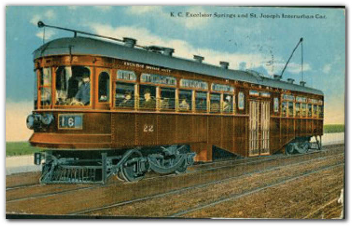
The message on this Hall Brothers color postcard mailed on April 24, 1917, to Miss Lula Mercer, care of The Hotel Washington, room 516, Portland, Ore. reads: “Dear Lula, I am leaving here this morning for Clovis, New Mexico. Write to me there. I will write you full details in a few days. I am headed back for the coast. I expect to be in New Mexico about two months.” Signed, “J.A.B.”
The card shows Car 22 of the Kansas City, Clay County and St. Joseph Railway, or Interurban, assigned to the Excelsior Springs or Clay County routes.
The K.C.C.C. St. J. Ry. Interurban had two primary routes between Kansas City and Excelsior Springs and Kansas City and St. Joseph.
Financed by philanthropic investors from New York and Boston, the line began operation in 1913 and was spurred on by the success of electric Interurban railways in other cities.
The cars were designed with steam railroad specifications instead of standard streetcar specifications, meaning the massive rail cars measured close to 60 feet in length and 9 feet wide and was capable of speeds upwards of 80 mph. The initial fleet of railcars, purchased from the Cincinnati Railcar Manufacturing Company, included 16 passenger cars, five express cars and five freight cars.
The line was an instant hit among area travelers who could now travel to St. Joseph in a little over an hour in the luxurious, high-speed electric train cars.
The line carried a variety of nicknames such as the Excelsior Springs Line or the “Red Line” after the car’s maroon coloration. The main line traveled north across the Armour-Swift-Burlington Bridge from roughly 8th and Walnut where the ticket office and depot were located. It then traveled up Swift Avenue in North Kansas City splitting near present-day Macken Park.
The Clay County route traveled east through Avondale, then following roughly the route of 69 Highway — Vivion Road — through northern Claycomo, Glenaire, Liberty and ultimately Excelsior Springs. The St. Joseph route traveled west along the bluff near the Kansas City water works, through Riverside and Northmoor adjacent to AA Highway — present day Waukomis Drive — up to the 68th street intersection. The line then continued north-northwest toward Drennon Stables, Ferrelview, Camden Point, Dearborn, Faucett and ultimately entering St. Joseph near 8th Street and Angelique. In an area known as “the flats,” north of Dearborn the trains often reached speeds of 80 miles per hour.
The Interurban ran its last scheduled train in March 1933. Ridership dropped drastically after the improvement of roads between Kansas City, Excelsior Springs and St. Joseph and the company’s profits tumbled. The company’s assets were auctioned off and Interurban cars were used for everything from diners to chicken coops throughout the area. Today, in some areas the old Interurban route can clearly be seen. Between Ferrelview and Dearborn, an 18-mile stretch of the old roadbed was actually graded and paved and named Interurban Road. The road runs through such old landmarks as Settles Road, Todd Creek or Sharp’s Station. North of Dearborn, the abandoned line becomes more obscure, traveling under present day I-29 toward Faucett and ultimately paralleling Sparta Road on the south side of St. Joseph. Parts of I-229 in St. Joseph run on the old roadbed.
If you’d like additional information on the Interurban go to www.interurbanroad.com. Additionally, local author and Historian Ed Conrad recently completed a new book entitled Heartland Traction: the Interurban Lines of Kansas City.